Verify the claim,
not the headline.
An open cryptographic evidence ledger that holds environmental claims and carbon market baselines accountable to raw Earth observation. Submitters package reproducible Sentinel-2 satellite telemetry, automated quality gates detect cherry-picked scenes and hidden calibration offsets, and every audit trail, challenge, and supersession is anchored immutably on Ethereum Sepolia — with zero backend trust.
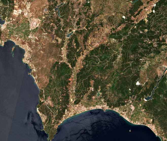
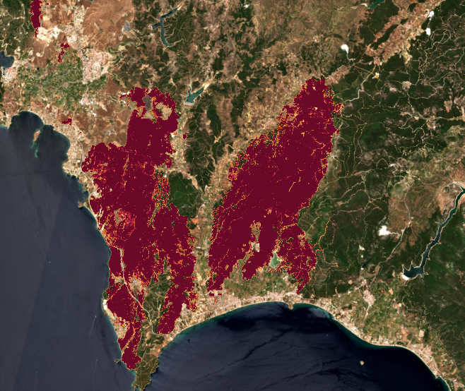
Real Copernicus Sentinel-2 L2A 20 m COGs via AWS Open Data. Drag slider to wipe between 25 June pre-fire baseline and 5 July contained burn scar. Raster dNBR is computed by the open CLI; the browser hashes, gates and anchors. No simulated panels.
Today on the desk
Drafts you build in Submit live only here until you anchor them with your wallet.
New submission →Review queue
How a claim moves
- SubmitWizard builds an RFC 8785 envelope for any tile and hashes it in your browser.
- GatekeepFive gates check envelope, bounding, census/timing, calibration/sensitivity, recovery limits.
- InspectAuditors interrogate curves, four-date imagery and the map before deciding.
- AnchorWallet-signed Sepolia transactions make reviews and challenges permanent.
Honest boundary: the browser verifies envelopes, method disclosure and anchored evidence. Pixel-level dNBR for a new tile is computed by the open CLI (izmir_dnbr.py pattern) and its outputs are hashed into the package — the UI never invents raster results.
Interact directly with the ground-truth evidence
Traditional climate reporting presents a static burn hectare headline. CCEL allows you to independently wipe between satellite acquisitions, inspect the 4-date multi-temporal census, and drag the burn-severity threshold to expose hidden sensitivity and calibration biases.
Pre-Fire · 25 June 2025
Contained · 5 July 2025 (9,726.2 ha)
Intact pine forest and maquis, four days before the 29 June 09:57 UTC ignition.
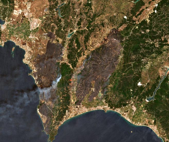
1,957.5 ha under active smoke / dark char (SCL 2 & 7). Fire B still spreading.
Smoke-free perimeter. +1,917.6 ha (+24.6%) of post–30 June expansion revealed.
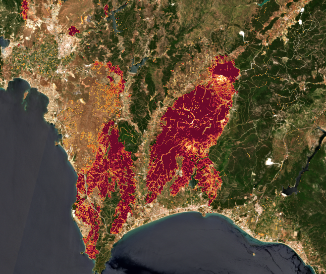
1-year anniversary (25 June 2026): Mean NBR over burned scar shifted from −0.6205 to +0.1619 (herbaceous rebound, not replanting).
Interactive Threshold & Method Sensitivity
Drag the threshold slider to see how a single reported hectare number is unscientific without publishing the full curve and calibration offset.
Across dNBR 0.15–0.44 the estimate spans 7,963.1 → 7,227.7 ha (735.4 ha). Omitting ESA Processing Baseline 05.xx additive offset (BOA_ADD_OFFSET = −1000) causes an artificial undercount of −1,703.6 ha (−23.6%). Publishing the curve — not a point — is the reproducibility requirement.
A claim cannot outrun its evidence
Four deterministic verification guarantees executed directly in your browser and anchored on Ethereum Sepolia — replacing unaudited PDF claims with verifiable satellite telemetry.
Anti-Cherry-PickingExhaustive Scene Census
Multi-catalog STAC pagination (284 scenes) flags omitted clearer or post-containment overpasses automatically.
Anti-Single-Point BiasMethod Sensitivity Disclosure
Mandates 6-tier USGS curves and ESA baseline calibration (BOA = −1000), eliminating hidden offset distortion.
Permanent Audit TrailImmutable Lineage & Timing
Disputes and supersessions stay permanently on Sepolia in an acyclic DAG. Retrospective rules are flagged POST_HOC.
Zero-Backend TrustPure Client-Side Proofs
Browser WebCrypto computes canonical JSON (RFC 8785) and Merkle roots (RFC 6962) with Python byte parity.
From Raw Satellite Telemetry to Cryptographic Settlement
Every step of the verification pipeline is deterministic, client-verifiable, and reproducible. Click any architecture node below to inspect its data routing, mathematical formulas, and cryptographic invariants.
Exhaustive STAC pagination across AWS & Planetary Computer (284 scenes). HTTP Range streaming of 20m COGs.
Applies ESA Baseline 05.xx offset (BOA = −1000). Publishes full 6-tier USGS sensitivity curve.
Pure client-side canonicalization (JCS) and RFC 6962 binary Merkle tree with Python byte parity.
Runs 5 automated gates in browser: Merkle integrity, bounding, STAC census timing, sensitivity, recovery scope.
Anchors submission, watchdog disputes, adjudications (NEEDS_EVIDENCE), and immutable supersession DAG.
Copernicus Sentinel-2 L2A & Multi-Catalog STAC Router
Queries AWS Earth Search and Microsoft Planetary Computer STAC APIs with paginated exhaustion across the monitoring window. Streams only the required bounding-box pixel blocks of 20m Cloud-Optimized GeoTIFFs (B8A, B12, SCL, TCI) via HTTP Range requests without downloading gigabytes of unneeded spectral bands.
MGRS Tile 35SMC · S2B_35SMC_20250705_0_L2A
Why it matters: Eliminates selective scene omission (cherry-picking dates with heavy smoke or before the full perimeter was contained).
Case registry
Every anchored package and every local draft in this browser. Anchored verdicts come from Sepolia; drafts are explicitly unanchored until a wallet signs them.
No cases match. Clear the search or submit the first claim for a new tile.
Select a claim package for review
The submitter packages boundary commitments, satellite scene IDs and radiometric metrics into a canonical envelope. Pick a package — the gatekeeper in Step 2 re-evaluates instantly.
0x…
0x…
Honest prototype boundary: this build implements one module — Sentinel-2 L2A Wildfire Disturbance & Recovery on tile 35SMC. Arbitrary documents without spatial / radiometric parameters are rejected by the gatekeeper. No fake generic upload.
What was checked — and what needs evidence
Five independent gates run against the public Sentinel-2 archive, reproducible query logs and the submitted method. Hover any card — every verdict traces to a number in Step 3.
Multi-date census, single-tile bounding, calibration offset, and recovery boundaries verified.
Checking observation timing, active smoke coverage and threshold sensitivity disclosure…
June 2025 İzmir / Orhanlı wildfires — the evidence
How much land appears burned, how sensitive is that estimate to imagery and method, and can another reviewer reproduce it? — NERO Research Brief (Coskuner & Papavasileiou, 1 July 2025) vs. reproducible CCEL dNBR.
BOA_ADD_OFFSET = −1000 underestimates dNBR ≥ 0.44 by 23.6%.Figure 1 — Threshold & method sensitivity
Why a single number is not reproducible without its threshold and calibration offset.
| dNBR threshold | 30 June total | 30 June A / B | 5 July total | 5 July A / B | Expansion | 30 June raw DN |
|---|
Across dNBR 0.15–0.44 the 30 June estimate spans 7,963.1 → 7,227.7 ha (735.4 ha). Publishing the curve — not a point — is the reproducibility requirement.
Figure 2 — Four dates, one scar
Pre-fire baseline → active-fire smoke → contained perimeter → exact 1-year anniversary. Spectral rebound is shrub resprouting — not proof of replanting or carbon recovery.
Pre-Fire · 25 June 2025
Contained · 5 July 2025 (9,726.2 ha)
Intact pine forest and maquis, four days before the 29 June 09:57 UTC ignition.
1,957.5 ha under active smoke / dark char (SCL 2 & 7). Fire B still spreading.
Smoke-free perimeter. +1,917.6 ha (+24.6%) of post–30 June expansion revealed.
Exact calendar-day match. Persistent scar vs. herbaceous resprouting — not replanting proof.
A ledger that cannot erase its corrections
PDF reports erase failed audits. Here, submission, watchdog challenge, adjudication (NEEDS_EVIDENCE), supersession and approval stay permanently on Ethereum Sepolia — including the honest POST_HOC timing flag.
Demonstration Disclosure: The Submitter, Independent Wildfire Auditor, and Lead Verification Reviewer roles are demonstration wallets controlled by the team for this testnet deployment.
| Event / Transaction | Actor | Status | Cryptographic link |
|---|---|---|---|
| Loading on-chain events from Sepolia… | |||
Recompute it yourself.
Single tile 35SMC (EPSG:32635) · rows [3434:4542] × cols [4036:5352] · 1,108 × 1,316 px at 20 m · 16 COGs range-fetched with SHA-256 provenance.
RFC 8785 + RFC 6962
Canonical JSON (JCS) and domain-separated Merkle trees with byte-for-byte Python ↔ TypeScript parity. One flipped byte breaks the Sepolia commitment.
canonicalize → SHA-256 → Merkle root → on-chainBOA_ADD_OFFSET = −1000
ESA PB 05.xx calibration applied. Skipping it costs −1,703.6 ha at dNBR ≥ 0.44.
0 discrepancies
Paginated STAC to exhaustion — AWS Earth Search × Planetary Computer, hash-logged.
CLI reproduction
PYTHONPATH=packages/cli ./.venv/bin/python \
  packages/cli/ccel_cli/izmir_dnbr.py
bash scripts/verify_all.sh   # 6 stages
POST_HOC ≠ PRE_REGISTERED
A rule committed today cannot prove it predates historical imagery. The chain says so.
Technical drawer — tamper simulator & embeddable badge
1-byte tamper simulator (WebCrypto)
Corrupt one byte of the reported hectares and watch RFC 8785 hashing diverge — Check 1 in Step 2 flips to TAMPER DETECTED.
Embeddable verification badge
Registries embed <climatechain-badge> to hydrate status live from Sepolia RPC.
Submit an environmental claim for review
Build a real evidence envelope in your browser. CCEL canonicalises it (RFC 8785), hashes it with WebCrypto, previews the five gates, and saves it as a draft you can anchor on Sepolia with your wallet. Raster dNBR for new tiles is computed by the CLI — the generated command is part of your package.
On-chain anchoring
The contract is the system of record — there is no CCEL backend database. Submissions, challenges, adjudications and approvals are wallet-signed transactions; anyone can re-read them.
Tx 0 rule (POST_HOC) · Tx 1 submit · Tx 2 challenge · Tx 3 NEEDS_EVIDENCE · Tx 4 supersede · Tx 5 APPROVED
Full event table in workspace →Connect to anchor drafts, challenge packages or (as reviewer) record decisions.
Timing honesty is enforced in the contract: a selection rule registered after the monitoring window is permanently marked POST_HOC. Full hashes, actors and Etherscan links are in the case workspace (Step 4).
Test the gates with claims designed to fail
Nothing here is hard-coded theatre: Claim A–C verdicts are recomputed from izmir_orhanli_audit.json at runtime; Claim D runs the production serial-overlap detector (detectSerialOverlaps) — the double-counting guard for carbon retirements. A credible market needs all four behaviours.
Core integrity design: a claim cannot outrun its evidence
- Census, not cherry-picksPaginated STAC to exhaustion, hash-logged. Omitted clearer/later scenes are detectable — İzmir v1 hid +1,917.6 ha that way.
- Sensitivity, not single points735.4 ha hides inside threshold choice; −1,703.6 ha inside one forgotten offset. Curves are mandatory disclosure.
- Uniqueness, not double countingRetirement serial blocks are interval-checked across the package; overlaps flag before credits move.
- Corrections, not erasuresChallenge → NEEDS_EVIDENCE → supersession stays on Sepolia forever, POST_HOC timing included.
Production path (no-backend architecture)
- NowBrowser hashing/gating + wallet anchoring + CLI raster evidence. Works today, zero servers to trust.
- NextGeneralise CLI dNBR to any MGRS tile (STAC search → COG range fetch → audit JSON), IPFS pinning of envelopes, reviewer wallet allowlist UX.
- ScaleIndexer for registry discovery, RSS/webhook alerts on challenges, multi-module gates (deforestation, mangrove) behind the same envelope.
Prove the product works — live
Each row executes in your browser against the real fixtures and Sepolia RPC — the same code paths the workspace uses. Server-side suites (Python dNBR, Foundry, on-chain state) run via bash scripts/verify_all.sh.
bash scripts/verify_all.sh
# [1] secret guard · [2] pytest (dNBR) · [3] forge test · [4] web tests + build
# [5] CLI package + census replay · [6] Sepolia on-chain state